Explore the available Super Randonnee courses and detailed ride information.
What is a SR-600 Super Randonnée?
A SR-600, also called ‘Mountain Brevet’ has similarities with a permanent, but is subject to special rules. The courses are little over 600 km and are very challenging, involving much climbing. It was initiated by our parent organization ACP, but is now moderated by a separate organization called Provence Randonneurs. Provence Randonneurs (in France) manages route approval, homologations, the ‘SR-600 award’. The liaison in Korea Randonneurs is Mr. Youngsam Kim (samnim33@naver.com). Finishing a SR-600 does not attribute to an ACP award, but does count for Korea Randonneurs awards. It is not recognized as a 600K brevet, so it does not count for obtaining SR status. Each SR-600 can be done in 2 versions: the R (Randonneur)-option and the T (Tourist)-option. The difference is determined by the rules, see below. The reporting at the start, at controls and at the finish, is by Kakao Talk to Jan Boonstra (010-8915-7046), identical to reporting in permanents.
- In a permanent, only the controls between start and finish have a CP number, in SR-600 the start is CP1 and the finish has the last CP number.
- In SR-600 the control photo must not show the rider, but the bicycle with frame badge instead.
- The registration procedure is different from brevets and permanents
Rules
- Distance of the course is between 600 and 620 km
- Minimum amount of total climbing: 10,000 m
- Time to complete the R-option: 60 hours
- The T-option must be completed with a minimum of 75 km per day.
- Safety gear for bike and rider are the same as for permanents, as well as signing a waiver form and sending it by photo at the start
Registration
To apply for riding a SR-600, send an email to Mr. Youngsam Kim (samnim33@naver.com), at least 10 days before the intended day of starting. The email must contain:
- The SR-600 code (see “SR-600 Courses”)
- Choice between R-option or T-option
- The member number(s) and name(s) of the rider(s)
- The intended day and time of starting (R-option only)
- The control point (CP) of starting, if it is not the regular start/finish point
The applicant will receive a frame badge (to attach to the bicycle frame) and an SR card, to use during the ride and the instruction to pay 34,000 won. Refund after cancellation (minus 5000 won admin costs) is possible after returning the unused SR card and frame badge. Change of date can be done up to one week prior to starting. After starting the SR, the card and frame badge are not valid anymore for another SR-600.
Preparation
Download the route information in GPX format, the waiver form and the control points information. Make sure yourself and your bicycle are in order in compliance with the safety rules. Attach the badge frame in such a way that it is visible on control photos.
Summary of the Super Randonnée routes
Click on the number to access the relevant SR Information Page.
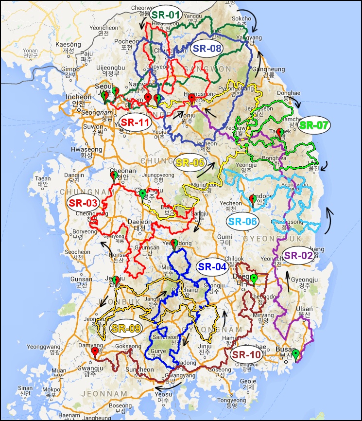
Summary of available Super Randonnées
Click on the code to access the relevant information page
| Code | Name | Distance | Climbing | Start in | Finish in | Designed by | |
|---|---|---|---|---|---|---|---|
| There are no posts | |||||||
SR-600 Reporting
-
1. At the startSend in Kakao Talk text message to Jan Boonstra:
- Your name
- Your member number
- SR-code
- Start CP (in case the start is not at the regular start/finish location).
Make a photo and send it before starting, of:- Waiver form
- The bicycle with frame badge and the starting point, clearly identifiable.
Then start, your starting time is the time of sending the start photo.
WARNING: The correct sequence of control points must be followed. Riding in opposite direction is not allowed -
2. At Controls
- Send in a Kakao Talk message: the CP number (only the CP number please)
- Make and send a photo showing your bicycle with the frame badge and the control point, clearly identifiable. Send the photo right after taking. Consult the control information what is required on the photo.
NOTE: receiving a stamp on your permanent sheet (for instance at a 사대강 인증센터) is possible and can replace a photo. WARNING: When you do not start at the regular start/finish (S/F) point, then the regular S/F point must be regarded as a control. Example: when you ride PT-98 and start at CP4, the sequence of your reporting is: CP4 (start) – CP5 – S/F – CP1 – CP2 - CP3 – CP4 (finish). Failing to include the S/F as a control results in DNF. -
3. At the Finish
- Send in a text message: “finish” or any similar remark in Korean or English, making clear that you finished the ride.
- Make and send a photo as on a control point. The time of sending the photo is your finish time.
- Your riding time will be reported to you by a Kakao Talk message. The updating of your result, with the homologation number in your personal records my take a few days.
-
4. “Best Rider” award
Also with SR-600 rides, members can collect marks for good reporting. The marks won from SR-600 are mixed with those won in permanents. See chapter Permanents for details.
Procedure of making a proposal
SR-600 courses are typically made by enthusiastic randonneurs. The procedure of proposing and the design restrictions are the same as for permanents. When you have the intention to propose a SR-600 course, contact Mr. Youngsam Kim first at samnim33@naver.com . Then you will be guided about what to do and to whom to send the documents. In Korea, SR-600 courses typically have the name of an animal.
Finally, an SR number is assigned and the website will be updated with the new SR-600, after approval of the course by Provence Randonneurs.